NYC's Outdated Flood Maps Leave Thousands At Risk For Disaster Bills

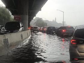
New York City’s flood maps haven’t been updated in 14 years, potentially putting tens of thousands more New Yorkers in harm’s way and leaving them without a means of paying for damage if a storm should hit.
That’s according to researchers at the New School, who tracked new construction and population changes in six flood-prone neighborhoods between 2007 and 2018. Currently, a Federal Emergency Management Agency (FEMA) map last updated in 2007 determines how much of New York City is at risk of flooding—and which homeowners are required to reference by law when purchasing flood insurance.
The study shows that due to a steady stream of building developments, these high-risk flood zones have become denser, putting more people in these budding communities in the path of dangerous and destructive floodwaters than before Superstorm Sandy. Income levels have dropped across some of these neighborhoods, making it harder for them to prepare for future natural disasters.
And the current flood zones in these neighborhoods are potentially 46% larger than they appear on the official maps in circulation, the researchers found.
“Flood risk is much more complex than a hard-drawn line that identifies what is and what isn’t,” said Pablo Herreros-Cantis, a research fellow at the New School’s Urban Systems Lab, who presented the work in June at a climate conference organized by Columbia University’s Earth Institute.
FEMA proposed an updated map for New York City, which found that twice as many buildings as before were at risk of flooding. It was supposed to go into effect in 2015, but the city appealed it, arguing that its flood zones were overestimated and would force homeowners to buy unnecessary or overly expensive insurance. A new floodplain map is due out in 2024, but in the meantime, developers and homeowners are operating off the outdated version. (Developers building in the proposed flood zone do have to include some resiliency measures until a new map is ratified, according to the city.)
To get a clearer picture of the current flood risk, Herreros-Cantis and his team focused on six neighborhoods across the five boroughs: City Island/Co-Op City in the Bronx, Coney Island in Brooklyn, the Lower East Side and East Harlem in Manhattan, the Rockaways in Queens, and Stapleton in Staten Island.
